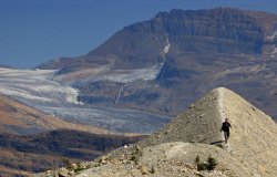
The waning days of the Canadian expedition were upon us. We studied the maps, looking over our options. The Kootenays had a pretty nice hike along a ridge, though that meant 180 degrees of rock wall. Banff didn't seem to have any very exciting hikes without getting into multi-day treks we lacked time for. And Yoho had the Iceline Trail which seemed a good way to get in some alpine meadows, glaciers, waterfalls, and exercise all at the same time. So we set sail for Yoho early in the morning, encountering the Spiral Tunnels on the way there. These are a series of tunnels in the mountain that essentially spiral down gradually so that the trains can lose or gain elevation without a steep grade. Many trains and lives had been lost on this stretch before turning to the Swiss for a solution and since the 30s it's been working beautifully. As we watched the train reappear above itself and the front of the train cross over the back, we didn't realize we'd be wishing for a similar device on the Iceline trail later that very day.
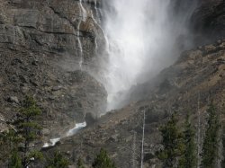
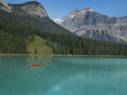
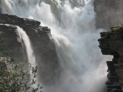
After arriving in the parking area for Yoho and fixing lunch, it was time to see off. The first stop was Takakkaw Falls, Cree for Magnificent, and that it was. At around noon it was a good time for photographs and Dan and I spent some serious time with our cameras putting off the hike. And then the Iceline Trail was upon us. Most people do not do the trek in the way that we were setting out. Going to Little Yoho via the Iceline Trail meant a very steep ascent to the mountain tops and then an undulating ridge walk before a moderate descent. In contrast, the lower path allows a first day (fully laden, by the way, with all the food) of gradual climb in the shade of the valley floor to the campground at Little Yoho followed by a second day with a moderate ascent and a steep descent. Makes a lot more sense, yes, but for the sake of lighting in our photos we went the path less travelled.
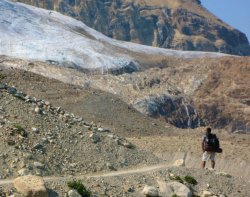
Unfortunately, it didn't make much difference. The skies were hazy from BC Forest Fires which eliminated any great panoramic vistas we may have captured. Additionally, a lot of what we wanted to capture was actually UP the ridge rather than down, meaning we'd timed our hike all wrong. Nevertheless, it was a beautiful hike along what felt like dozens of glaciers at a high altitude in great weather. Not so great for hiking with 20 kilos on our backs, but great in that it was sunny, hot, and aside from the haze, clear skies. We were frustrated repeatedly by inaccurate trail markings, almost all in blatant contradiction to our map which had deficiencies all its own. How this is possible in the age of GPS is beyond me, but this has been a recurring and embarassing theme throughout the national and provincial parks we visited. Nevertheless, while demoralizing to our ego (it only said 5 km, it HAS to be over THIS ridge) we did eventually arrive, 11km later, in Little Yoho.
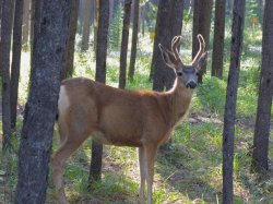
The campsite was nice and we met some cool people travelling from all over the place, but as the sun went down fatigue overtook us and we were out like the proverbial light. The next morning I woke up earlier than Dan and got coffee, tea, and breakfast going. After a hearty bowl of oatmeal and bananas we pulled up stakes and hiked back out the lower trail, 9km, past Laughing Falls and one of the highlights of the trip. A biiiig black bear, in the woods, no more than 20m from us. Dan heard the crack and held his hand for a stop and we stood listening and looking into the shadows until the shadows moved. I started to open my camera case and Dan looked at me sharply. "What are you doing?!" he asked. "Getting my camera," I impertinently whispered back. It was a waste of time perhaps, but it could have also been an excellent shot. The bear inched towards us and we backed away. It ventured further and we took our leave. But at last, in the middle of the forest, no roads in sight, and we had seen a wild bear. Yoho had delivered what every other park (aside from Jasper, which compromised with a cub near the roadside) failed to deliver.
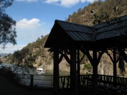
From Yoho, we stopped at our old campground in Lake Louise for a quick shower then drove up to Banff, picked up a few groceries for today and tomorrow, and set up our camp, unfortunately, at the camp far out of town. It was huge and it was absolutely empty. We basically had 1500 campsites to ourselves. Or at least at first. We did get some neighbours, including a creepy old man with a van that looked like it might have been an accessory to various crimes over the years. Did I consider sleeping with a knife? Yes. But we slept and awoke alive as you may have guessed, with nary a blood-curdling scream the whole night. It was now August 30, the last day. In fact, I was flying home that evening at 9 PM. So we had a pretty relaxed last day. We walked to, and up, Sundance Canyon which was more of a stroll than a hike. And we enjoyed the end-of-summer warmth by relaxing alongside a nice and quiet lake (the name of which I don't remember) while in the car, Dan's computers burnt my photos onto DVDs.
Returning to the city was mostly a relief. It had been a great two weeks, we'd gotten a lot of exercise, seen a lot of beautiful places in Canada, and lived a pretty simple life. It was a great time. But I was happy to be back to civilization, to know that I would be sleeping indoors for the first time in two weeks, with all the comforts of home. As great as it was, we kept up a pretty hectic pace and I was ready for a little sedentary activity. Dan and I went for some pasta at a restaurant near the airport and said our farewells. He was off to the border for Glacier National Park, and I was on a plane for Saskatoon. That is, after a little time in the Chinook Lounge enjoying the sunset, a bag of chips, and the better part of a bottle of wine. Night fell, and outside the garish orange light of the city a vast wilderness awaited.
It was nice to be home. Sept 1 was my birthday and I had a few quiet drinks with some friends after going out to dinner with the family. Sept 3, Franz Ferdinand was in town, and I attended with John, Leona, Kirk, Darren, and Larissa, forced to sell my last two tickets because I don't have enough friends with good taste in music. Too bad, because it was amazing. Such a great show! But ridiculously hot, standing outside after when it was still 25 Celsius, the open doors felt literally like an oven, people escaping drenched in sweat. Larissa soon after left for Mexico again, to work in a resort and probably more importantly visit Julio. And the rest of September and October disappeared in a blur as I prepared for the next big trip: half a year in Central and South America. Leaving October 28.
Canada’s a big country. And if I may be so bold to say, it’s a beautiful country. So for a road between two places to be considered a must-do in this country, well, that’s quite a big deal. For it to be consistently considered one of the top 10 drives in the world, well, frankly, it’s a little difficult to swallow. It’s a big world out there and I like to think that I’ve seen a fair amount of it. Notable drives for me are the road to Andalsnes and beyond to the fjords in Norway, the road to Vang Vieng from Luang Prabang in Laos, the cobblestone silk road from Shangri-La towards Tibet in China, the dirt and sand 4-wheel-only Gibb River Rd through the Kimberly of Australia, and while the Great Ocean Road is an obvious choice from that country, I’d nominate the road south of Kalbarri over top of it. This is some tough competition and as much as I’ve travelled, I haven’t scratched the surface of the globe yet. So tough to swallow, yes, but then you consider the beauty of Banff and my newly discovered appreciate for the splendours of Jasper. And you think that this is a road that connects these two great parks along the spine of the Rockies, passing glaciers, azure rivers, mirror lakes, and waterfalls and you realize that not only is it possible... it’s downright obvious.
And better still, it’s on the agenda. As a very plump cherry on top of this proverbial cake, the weather was perfect. Simply perfect, and this coming from Dan, who hates a clear blue sky because it makes his photos too boring. It was a warm mountain morning, the clouds from last night were breaking apart and going their separate ways, and we were on the road again. I won’t bore you with every single detail, but if there was a place to stop on the way, we would. It was as simple as that. There were certainly places along the way we never hiked in order to take advantage of this day and see the road in its entirety, but we stopped and considered every time. No serious hikes today, however. It was all road. The road itself was photo worthy. It climbed inexorably up, only to plummet down equally fast. It came around in large loops and switchbacks, so that you could see it wind its way down from you and cut along the valley floor like the contrail of a jet engine. It crossed rivers, came all but right past the bottom of the Athabasca glacier, endured metres upon metres of snowfall (in other seasons) and still here it lay, a thin ribbon of civilization. Which is the reason that several of my photos (including one of my favourites – a panorama of the North Saskatchewan River) include or even focus on the road. In case you were wondering.
We stopped many times along the way, many many times. Sometimes it was to look at (or photograph) distant mountains or waterfalls, sometimes for a hike and sometimes just for a little photographic leg stretch. The landmark site on this trail is without a doubt the Athabasca glacier. My grandpa remembers it coming right to the highway but it is nowhere near anymore. Even having receded well back into the mountains, it is still grand, flat, and – although they discourage it – walkable. We parked, had lunch, and then set out up the glacier. There are definitely cracks, and I won’t deny a little unease at crossing near them or even near the small melt streams that amble down the glacier’s face, but plenty of people were walking around and taking their chances aside from us, and both Dan and I have done some glacier hikes in the past. All told, we were probably on that glacier for two hours and it was beautiful. The melt streams I mentioned glowed an iridescent blue, almost unbelievably. As we climbed higher the air blowing over the ice grew cooler but the sun was shining and it was a perfect day for not only our drive but also our climb. The view across that valley was beautiful but hard to capture and soon we were farther along than even the guided groups were venturing and it was time to turn back. But not before some silly photos attempting to look cool and jumping across melt streams.
The second highlight, was crossing the North Saskatchewan River at Saskatchewan Crossing. The colour was like any other river in this part of the world: spectacular. By the time it comes through our neck of the woods, it is a dark blue but here it practically glowed. It somehow made me appreciate the great water we have back home (even though it is the South Saskatchewan that flows through Saskatoon) to see it here in pristine and untouched form. I also managed to get one of my favourite photos on the entire Canadian Expedition right here on this bridge. You’ll have to trust me that it looks great at full size. We also had a lot of fun stopping along the lakes and vying for the best photo, a contest I may have been doomed to lose from the beginning. To be fair, I did initiate the inclusive of the purple flowers into the photo, but Dan had the best technique and he got a great photo of one of the lakes with distant mountains reflecting and of course purple flowers in the fore.
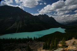
And the final highlight caps the Icefields Parkway on the southern side: Peyto Lake. Named after “Wild” Bill Peyto (you probably remember the saloon named after him in Banff), this lake is probably the nicest among scores of world class lakes on the drive. We parked, made our way, waited for the tour bus of people to disperse, then hopped the fence to get some good photos. A German woman called out “Excuse me!” which Dan didn’t hear (though I did). Then “we’d like to take a photo,” to which Dan replied, “I’ll just be a minute”. At this point her husband piped up, “We’ve been here already for 10 minutes” and Dan, “No you haven’t. WE haven’t been here for 10 minutes” “Well, maybe five minutes” the man replied, but he’d already lost. Now, this isn’t a confrontation I’d like to have, and I definitely can appreciate wanting people out of your photo, but it seemed they were going a bit far. Dan’s responses were rude and I felt embarrassed, but then they were pretty rude to begin with. Why is their photo more important? We really had only been there for about two minutes and I’d already gotten out of the way behind a tree for their benefit. The more I thought about it, the more it was just kind of funny.
Anyway, we got our photo of Peyto Lake, though the light wasn’t ideal it was still pretty nice. Still, Dan wanted to come back in the morning for another photo and I was up for it. We had now entered Banff National Park, incidentally, and we found a nice campsite in Lake Louise then came back the next morning. I was shocked at how much more beautiful this lake looked lit from a different angle. In fact, I was shocked it could even look better than it had the day prior, but here was evidence. You can be the judge, too. From Peyto Lake, we drove down to Bow Lake to look around and then to Lake Louise. I had to the overpass many a time, turning to go ski the slopes at LL, but only once before had I been to the actual lakeside, when I was very young. I don’t really remember it even, but I have seen photos. So it had a sort-of familiarity that probably wasn’t merited but there it was.
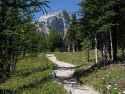
We set out from the hotel at the base of LL to hike to the glacier that backs it, specifically The Plain of the Six Glaciers trail. It takes you along the edge of the lake and then up into the mountains for, you guessed it, a view of six glaciers up there (though I only saw five). There’s also a teahouse up there for anybody looking for an excuse to exercise that doesn’t involve scenery or photography, but we didn’t stay for tea. We had another walk to Mirror Lake off the upper trail back, so we didn’t have to double back on our trail. All said, it was 16 km on top of some early morning photography. The trail was nice and the hike was worth it, though next time I’m going to have some mountaintop tea. Maybe because it was tradition in Asia, maybe because I like the idea of doing something patently out of context on a mountaintop, like sipping tea, I’m not sure. But it felt wrong to skip it.
Our third day brought us to something that Dan had been looking forward to since the airport in Vancouver – Morraine Lake. In fact, I think that a friend’s photos of Morraine Lake are what brought Dan up to Canada in the first place. We caught Lake Louise at sunrise and were at Morraine Lake to take photos for the golden hour, which in this particular location’s case, was 10 or 11. Climbing up to the vantage point I took the unfortunate path of walking across logs in shallow water, not realizing until too late there had to be a better way. Which was right when I slipped in. I sloshed my way to the top of the rock pile that gives Morraine Lake its name and there was the million dollar view. Or should I say twenty dollar view – the view spread out in front of me is one that I’ve seen many (well, not as many times as I’d like) times before: on the back of our old $20 bill. A solid hour of scrambling and attempting different photos while trying to dry my socks and shoes and having a snack later, we were back at ground level and setting out on our next hike: a three hike combo of Larch Valley / Sentinel Pass / Paradise Valley.
The hike would take us over the back of Morraine Lake through an alpine larch valley (appropriately named, you see) to Sentinel Pass, which rose between two mountains and featured tall stalagmite-like pillars of stone rising like guards (or sentinels, if you will) watching both valleys. From there it was a scramble down some pretty loose scree to Paradise Valley which, to be honest, was a rather boring hike with a few nice spots spread way too far out and guideposts that displayed random numbers of kilometres. The whole deal was 17 km and we had to hitchhike back to the base of Morraine Lake. Well, by we I mean one of us (it’s scary to pick up one person much less two). Dan tried first and was on his last car before it was my turn when some people pulled over and drove him down the road where we were parked. Dan picked me up, again, and our last day was concluded. Tomorrow, we were crossing back into BC to visit Yoho National Park, then back to Banff for a day before it was time for me to get home and Dan back to the States.
In spite of the fact that I live only six or seven hours from Jasper, I have never spent any time in this national park. I drove through it once upon a time on the scenic road to Victoria, I think in 1995 or 1996. I remember wanting to drive because everybody was tired except me. But that’s irrelevant. Dan and I were here, now, and it was our plan to explore the park thoroughly. After stopping at the park ranger’s office for tips, we decided to hike Geraldine Lakes. We drove south towards them, the weather growing increasingly cloudy as we made our way there. After climbing a windy logging road, we set off but did not get very far before the rain started. We’d reached the first lake, about 3 km and decided to press on. With every step, the rain grew heavier, the rocks more slippery, but still we trudged. There was a loud crack and lightning lit the sky and that’s when it happened.
We decided to turn back. I hate to turn back, to give up, but it made little sense to continue. We could see up to the area we’d be climbing to reach the second and supposedly more beautiful Geraldine Lake and it appeared to be the epicentre of this storm. We turned around and hiked the other 3km back to the car. Nature: 1. Man: 0. Looking north towards Jasper town, the sky appeared clearer, so we backtracked to Mt. Edith Cavell, which was a pair of glaciers, one melting with icebergs in the melt pool, the other dripping more traditionally from countless pores into small streams, waterfalls, and rivers. We hiked the trail down to the melt pool and took a look around before we decided to scale the massive scree pile and see what we could see. Now, on a nice day this would be a great vantage point. All we could see was the storm clouds we’d outrun earlier come hunting like Black Riders in Hobbiton, sneaking but determined up the valley, shrieking with every lightning bolt at our prior escape. We got back to the car just as the rain began.
At this point we gave up on hiking for a day and wandered the streets of Jasper. While Dan was talking to a friend on Skype, I wandered around a bit, settling on an old steam train set up outside the train station. It was pristine and had that certain mechanical romance that only the more simple machines of that era can hold and nearby there was an interview going on. When I got home, I discovered that my grandpa had been the engineer for this train, at least for a time, and that was just sort of a surreal discovery. Eventually Dan finished on the phone and another restaurant meal was not in the cards. We popped by the grocery store and picked up a whole chicken and threw it into a stew with corn, beans, rice, and potatoes. It was hearty, hot, and declicious and we only managed to finish half of it which meant we’d have a nice lunch for tomorrow.
That next day was a monumental day. First of all, I discovered why people often rate Jasper higher than Banff. The weather was better and there were too many options to count for outdoor activity. We drove to Maligne Canyon, itself a beautiful drive, and that brings me to the second reason the day was monumental. I spotted my first bear in the wild. Sort of. It felt like a bit of a cop out to see it along the road, but we came across a cub foraging and chowing down on berries along the Maligne River. It was safely distant but we were on the lookout for a mama bear nonetheless. And finally, the canyon itself was pretty nice, though touristy, but using Dan’s tripod I got a pretty cool shot of these two waterfalls within it. We also drove to Maligne Lake, which drains underground into the canyon, and this late in the year, had almost entirely drained itself.
The Malignes (French for wicked, by the way) were nice enough, but they didn’t compare to other things we’d seen. Then we drove south again, stopping first north of Jasper at Pyramid Lake, which was actually very nice, and then at Five Lakes. We hiked in and came across a slough where, according to the map (which in typical Parks Canada fashion was terrible), there was supposed to be one of the five lakes. We climbed a hill and no other lakes were there to be found. So we backtracked away, assuming that like Maligne they’d dried up, though deep down we both felt it quite possible we were wrong and hadn’t reached them yet. We considered telling a family walking down with fishing rods that there was none to be done but thought better of it. We may be wrong, there may have been lakes, and we also faced the danger of bursting out laughing.
The last stop for the day was the lovely Horseshoe Lake, seemingly abandoned except for some locals, this pristine lake has great spots for cliff jumping and all around was a pretty nice place to hang out. We weren’t prepared for the cliff jumping but we did hang out and watch others and with the sun beaming down it was a nice spot. Certainly, if Five Lakes had been anything like this we would have probably stayed there. But we weren’t going to be staying anywhere for too long. After all, I had to be home for the beginning of September, a Franz Ferdinand concert, and my birthday. It was my last one in the 20’s after all. So the next day, Dan and I set off south towards Banff. This is no routine drive, it is regularly rated one of the best drives in the world and you can see why. Next time, on The Life of I.
I actually woke up early for once; despite going to bed at 12:30, I was up at 5:40 and on the road with Andrew about an hour after that. As it was only the two of us, the itinerary was pretty much whatever I wanted within reason. We stopped for breakfast in Westbury and looked at a big map they have on the wall of Tasmania. As Chelsea would say, “It looks like a heart!” The itinerary was a stop in some caves, a short walk in Cradle Mountain national park, and then camp. But I saw the Walls of Jerusalem park, which I’d heard was beautiful right beside it, so the next thing I knew, we were making steam for the Moses Creek track, a track that is classified “T-4: No groups over four, no publication or images, etc”. That is, when we were actually on the track, but I’m getting ahead of myself. I would later refer to the track as the “Lord of the Rings” track, because you kept thinking it was the end and then half an hour later, you were still not at the troopy. But we did find our way back… eventually.
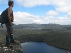
We started out in the conventional way. Fairly clear track, walk along it, la dee da, fork in the path, which way do we go? But soon we got onto a much less used track. To give you an idea of remoteness, we would be on this track for 9 hours of arduous hiking and not see another soul. We trekked through forest and came across an area that had burned about 10 years ago and not though it no longer looked charred it was definitely still a clearing. The next clearing we came to was a peaty meadow-bog, which had a grand looking mountain on the horizon. Mount Ragoona, I was told, and was surprised to learn it was our destination today. Not only was it high up there but it was not exactly nearby. We closed the gap by going off trail and far more vertical than winding our way along the track on the backside. This was a great success, and we were up in record time. Andrew thought we might as well go down the other side and around to a trail along a different lake and have a different hike back, which I liked the idea of. Sure, a little more tramping off-track, no problem. What that meant, I would soon learn, was rock climbing down part of the face (not too far, thankfully) and walking under, around, over, and usually right through thick bush. Combined with a long walk up and a treacherous trek down, this was exhausting. Not only was my knee getting sore but I was getting physically exhausted. Had I known we still would be walking 4 hours later, I might’ve stumbled and collapsed right there, probably right onto a snake; snakes were just one thing to worry about. And then we kept going and going and not finding the trail. We were supposed to hit it right before the lake but we were just about on top of the lake and, given the increasingly late hour, even Andrew was starting to worry when finally we hit it. Yes, it still took a long time to get back, but at least not slogging through scrub.
We made it back to the car at 6:30, which made it the longest walk Andrew had ever taken anyone on commercially. To celebrate and soothe our aching legs, we went an extra 40 km to get some beer. It definitely hit the spot. Camp was nice, they had showers and everything there, and I was out like a light not long after the sun. The next day, we went to Cradle Mountain after helping another guide get her van started – the other guide had left the lights on. It didn’t take much and we were standing at one end of Dove Lake looking up as it reflected Cradle Mountain looming over top. It was a beautiful sight to behold and we had perfect weather, nary a cloud in the sky. We made our way up to Marion’s Lookout looking over Crater Lake and while Andrew had a sandwich, I ran up further hoping for some better shots of the lake. Instead, Barn Bluff was sitting over the ridge waiting for me. But it was not to be. Back down and on the road, iPod cranked, sun shining, and a nice cold Boags in my hand and we were on the road looking for somewhere to camp. We crossed the Pieman river and took a bit of a jaunt up a road that Andrew had blockaded (it cut the world’s then-largest temperate rainforest in two and is now known by locals as the ‘Road to Nowhere’) when he was 18. There was nothing to see but forest on either side though, so I didn’t feel too bad about it.
We set up camp nice and early, much earlier than the previous night. Andrew put on some Xavier Rudd, John Butler, and then a third guy he’d heard of from a Canadian friend with some sitar. It was strange to look at the fire with this music – one of the logs looked like a dragon’s face, one that was unhappy – possibly because it was burning? The smoke came at me not long after I flunked this Rorschach test, as though it were being blown from the dragon’s mouth. I clumsily leaned to try to get out of the smoke and it followed as I almost fell out of my chair. Flames started to lick from the would-be dragon’s mouth as the sitar played loudly in the background, and the smoke relented and swung over to Andrew. He closed his eyes and time seemed to slow. It was a weird moment, I didn’t think he’d outlast the dragon and smoke engulfed him as white flakes of ash danced in the air. The smoke kept coming and he sat meditatively. And then, when I thought he could hold his breath no more, the smoke drifted away and he opened his eyes like nothing had happened. I had just witnessed an epic battle between man and nature, and he had no idea. I thought to myself that this must be what it’s like on some sort of hallucinogenic drug. As long as my imagination is this overactive, not only do I not need them (or want them), but it might be downright dangerous for me! At the very least, it told me that I should stop imagining I have any ability to write fiction.
The next day, we took a hike up Mount Donaldson, which was supposed to give nice views of the surrounding Tarkine forest and the ocean, but the weather was clouded and misty and we could only just make out the slightly darker line of the ocean on the horizon. We took a trip further down the coast and had lunch where the group normally camps. The west coast is open sea all the way to South Africa, so the surf is huge. Even on a day like today, where the waves were calm it was still an intimidating sight. We made our way further along to Zeehan for a chai latte and covered a lot of ground that afternoon, making our way on to a long a rugged 4WD track just past Lake St Clair which led to a pretty nice camp site. That allowed us to get an early start the next morning and have a good day hike in the lake area. The weather had been misty and cloudly all the previous day, so it was very nice that we had absolutely perfect weather. We climbed Mt Rufus into the sun, which offered some great views of the lake and valleys along. As it was such a clear day and the air was recently washed of impurity by yesterday's rain, we could see all the way to Frenchman's Cap and beyond from the top. The track back down was long and mostly uninteresting beyond the first bits, which were in 'marsupial lawns', grassy meadows in the middle of the scrub and of course walking along a ridge returning to earth.
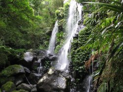
Camp that night was the best campsite so far, on the shores of Pine Tier Lagoon, a very Austrian-looking lake. On top of having a bit of a much-needed swim, we had a little wildlife show as a mother possum with a baby on top was lurking around camp and then a quoll was bounding around as well. We thought they might scrap it out but there was no fight that night. My final day in the bush was a trip down to Mt. Field National Park, home of the famed Russell Falls, which is probably the most impressive waterfall in Australia as well as a couple smaller falls, Horseshoe and Lady Barron. I did a circuit of all three while Andrew went to make lunch, as well as the Giant Tree walk. The giant tree walk is just that, a circuit among the tallest hardwood trees in the world, Eucalyptus Regnas. Some of these trees were 27 stories high. If you were to put one of these trees in downtown Saskatoon, it would make the highest mark in the sky. Only the redwoods of California, which are a softwood, are taller in all the world.
I did the loop and walked to what I thought was Russell Falls but was actually Horseshoe, and then down to Lady Barron falls after that. Then I returned to camp to discover I had not seen the main attraction and whatsmore, after dropping me off, Andrew had seen a Platypus. A Platypus!! I've been trying my whole time here to see a platypus and there was one right by our camp while I was wandering around in the woods thinking I should've stopped by a washroom before my hike. I went along the river hoping to spot it, but to no avail, and then came back and had hamburgers. Andrew and I hiked up to Russell Falls which was not running at full strength with the drought, but was still incredible, especially with a little imagination. There was a wildlife park nearby and we stopped there as there are supposed to be plenty of platypi around. Again, no luck. We also went up to some more really tall trees that were slated to be cut down until some protesters managed to save them, but the amount saved was not exactly generous. Then back to Hobart, for some pizza, a stay with Kerri (another couch surfer), and I was off to Melbourne and civilization once more.
I arrived at my Hobart hostel, City Central Backpackers, exactly when I predicted. The stroke of noon. The flight down to Tasmania, the last state to be explored on my rapidly concluding Australian journey, was pretty uneventful. My laptop battery didn’t last long playing a game of Civilization IV (when was the last time I played a computer game, I don’t know) and so I got started on my new book, The Kite Runner, which Daren and Janine had given me for Christmas. As much as I’d enjoyed reading Xenophon’s take on Socrates, I was looking forward to a more entertaining read, and right from the book’s first line, it delivered. But I digress. I met a Swiss guy on the bus into town staying at my hostel, and we chatted a bit as the bus crossed the Tasman bridge and the sky was suddenly filled with kites. It turned out, rather befitting my new book, there was a kite festival in town. As we couldn’t check in for an hour anyway, the two of us wandered in a direction we thought would take us back there. It didn’t, in fact, it was the complete opposite direction, but as someone once told me, “Adventure comes from poor planning” and indeed it did.
Having realized our mistake, by which I mean my mistake, we wandered back in the proper direction and took a walk through Battery Point en route to the park. I’d called Leo, a CouchSurfer, a local expert of sorts that invited Flavic (my Swiss friend) and I to take a spin with him to the top of Mt. Wellington and see the views. So, all that walking and we wound up back at the hostel instead, to check in and put our bags in our room before Leo met us at the botanical gardens. Unfortunately, ‘our’ room meant my room and his room, which had different numbers, floors, and locations, and we didn’t cross paths again. I went on to the kite festival myself, and noted, not for the first time, at how friendly Tasmanians are. Hardly a hint of the spinning dervishes I was expecting. Then, on to a quite long walk to the botanical gardens, through the memorial to the 500 Tasmanians that had died in the great wars (one tree for each soldier), where I looked around, snapped some photos, and read a lot more of my increasingly excellent book.
Leo met me there, eventually, and we drove up to the top of Mt. Wellington as promised. It’s a hard place to get to, unless you have wheels, which I was seriously contemplating. Tours up here are pricey and there’s no bus, but there WAS a long trail. It would’ve been doubly long as it was quite chilly at the top and I don’t have much left in the warm clothes department. We got some nice shots and Leo described the history, geography, and layout of his new home in Hobart. He kind of reminds me of Terry a bit, actually, and we got along pretty well. I met his two roommates and we had a bit of dinner there before meeting another CSer for coffee, whose name was Kerri. She was pretty nice, too, and I thought that I should’ve gotten more involved in this whole CouchSurfing community much sooner. Then we all parted ways and my first day in Tasmania was over.
The next morning, I got my life in Tassy sorted. I tried to figure out if there were any ‘adventure’ tours, by which I meant multi-activity. A bit of trekking here, climbing there, and so on. One of the things I really wanted to do in Tasmania was the Overland track, an eight day hike through some amazing terrain, but as I considered the other things I wanted to see and do and the fact that I had booked my flight back to Perth for the 23rd of January from Melbourne, time was not on my side. I found a company, TasSafari, that did do a lot of day hikes into some nice scenery over about 10 days, and given it was already the 7th of Jan and I really only had two weeks anyway, that sounded about right. It would give me a few days in Melbourne (I booked a flight that morning for the 19th) and let me get a rough scraping of the island, which was probably the best I could hope for. You can’t see and do it all, you really can’t. So I booked a tour leaving Hobart on Wednesday the 9th, and my Tasmanian experience was sorted. Having done this, I stopped by a travel agent to chat about my trip into Asia and was a bit discouraged that the requirements for proof-of-intent-to-depart were so strict.
I soothed my thoughts on this with a nice piece of pastitsio at a Greek restaurant in Salamanca Square, one of the better ones I’ve had from a restaurant (still nothing compared to Aunt Nicky’s), and sat in the sun reading my book. It reminded me of the month I spent in Crete, sitting in a café, reading my textbooks with a bowl of Greek salad and eventually yogurt and enjoying the afternoon. I felt relaxed here in Tasmania almost instantly. I walked around the city for a while and then met up with Kerri, who picked me up for a BBQ at her place where we also met another CSer, a Belgian named Will. We had a good barbecue, some nice wine, and a good chat before calling it a night. The following day, I got a few supplies, met up with Will for dinner and met a girl named Clare and some of her friends who were good fun, and played Wii and music and had drinks. When I was walking home, a girl pulled over to ask me where I was heading and if I wanted a lift, presumably because of my backpack and Canadian flag. Yes, these Tasmanians are a friendly bunch, and Hobart certainly was good to me.
Bright and early the next morning, 6:15 to be precise, I was leaving all that goodness behind and venturing up the east coast. I met my fellow travelers in our 4WD, loaded my bags, and jumped on. Mostly older people, though an Italian, Fabio, was my age, but they were all pretty nice. We drove up the Tasman peninsula to Port Arthur, a historic place where Tasmania’s first convicts were kept in quite brutal conditions. The security for the place was a line of hungry dogs on chains and the fact that it was otherwise isolated by water. Then we drove down to the peninsula’s southern point and walked, I’d say a good 15km to Cape Raoul, which was a beautiful walk. It starts in the forest making its way for the coast which is framed with some of the highest seacliffs in Australia. Once upon a time, a whole bunch of hot magma forced its way to the surface, only to stop short, buried by a bunch of soft sedimentary rock which over time was eroded away again. The result is a bunch of columns of rock shooting straight into the sky like the water being dashed against its face far below. There were plenty of spectacular views and it was a definite walk off the beaten track.
We caught dinner at camp, which was a bit late because our camp spot had been taken and we had to track down another one. Fabio and I shared a tent, we all shared some Boags, and we sat around the campfire and watched the stars start flickering on. My knee has been acting funny after lots of exertion lately, and it was pretty sore the next morning; I was and am a little worried about it, actually. We walked to Wineglass Bay anyway, because of clouds we didn’t climb to the top of Mt. Amos, and once it warmed up my knee wasn’t so bad. Wineglass Bay is an isolated beach on the opposite side of the peninsula from the main road, so the only way in is to hike. It is so named because the curvature makes it look like a giant wineglass filled with absynth. Again our weather was not so cooperative, but we went down to the beach anyway as the cloud finally started to break. It was beautiful from the bottom, bordered by orange-tinged rock (rusted iron deposits) and forest, and the sun was peeking out from time to time from the racing clouds not too far above. We set out for our second camp in an abandoned town on a mountaintop. The town is gone, but grassy plains remain and a lot of trails to nearby mountains and views. We had what has to be one of the best dinners I’ve had since I took Daren and Janine out to dinner, topped off with chocolate bananas (my first attempt at them) and I took a quick run up to the top of the nearest mountain before the sun went down.
The next morning we went back to that same mountaintop, and it was even more spectacular as the clouds rolled around in the valley below. We took a second walk through some forest to another lookout, and then did two walks in the Blue Tier forest. It’s a little bit sad that the Blue Tier forest is slated for logging. Normally, it would be protected as old growth forest (in other words, forest that has never been replanted) but as the result of a trench running through it, the entire forest is instead ‘re-growth’ and I hate to think that in a few years it won’t be there at all. Hopefully something is done about this silly classification system. Anyway, it was beautiful. There were some massive, massive trees (one 20m in diameter), lots of very old and tall fern trees, and a beautiful creek running through. We had lunch near the largest tree, which had a hollow cave in it that could probably fit 15-20 people and climbed back up. After some more backroads driving, we were off to Launceston to end the eastern leg of our trip with some parmy and delicious Boags beer. Now I have three nights here before catching the western side of the island-state and wrapping up my Tasmanian adventure.
The three nights in Launceston went quite fast. My first day was the arrival, which was marked by going out for dinner with the group. The second day, I walked around the city centre and bought some more shorts for the warmer climes and did the approximately 10km walk around Cataract Gorge, a beautiful gorge that’s literally a ten minute walk from the city centre. I walked all the way to the Duck Reach power station, which is pretty remote, and there were lizards everywhere sunning themselves on rocks. I was really hoping I didn’t come across a snake and kept a keen eye out but it wasn’t my day to get scrappy with the locals thankfully. On the walk they have a free swimming pool right on the river running through the gorge not to mention the nice walk. A very impressive park to have in a city. My final day I had planned to bike up to the Tamar Valley and do a bit of the wine circuit, but the wind was against the idea from the start, so I settled for a tour. And before I knew it, I was getting ready for bed to get up and head off into the wild west of Tasmania for a 5 day trip back to Hobart. Cradle Mountain, Lake St Clair, and who knows what else is on the itinerary, but I happen to know that I’m the only one booked on the tour and Andrew is my guide once again, so we should be pretty flexible and able to do some unique things. We’re leaving the trailer behind to get to some really off-the-tourist-track type locales. But that’s enough foreshadowing for now, I’ll see you soon.
We drove up the winding roads into the green mountains of Lamington National Park quite happily. They were fun roads to drive and it was nice to be in a car doing them. We’d hoped to get groceries and supplies in Cunanbura but there was little there, so instead we had fish and chips at a little chipper and hit the road. We camped just outside of O’Reilly’s famed resort (though I’m not sure why it’s so famous) and there were Wallabees all over the campsite – not to mention more bush turkeys. After deciding to stay for two nights so we could do a full day hike tomorrow, we set up camp and took a hike up to the Python Rock lookout to watch the sunset. It was pretty gorgeous up there and we crawled right out to the ledge and an overhanging rock to view it. It was a little scary but a great view past the trees and over the forest below.
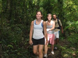
Chris and I went for dinner in the pub, but it was too pricey so I just had soup and we had a beer each and basically called it a night. It was pretty cool out here, which for me was just right. We got drizzled on a bit without our rainfly but nothing worth getting up to put it on and I finally gave up trying to sleep at about 6:30. Not the best sleep ever, and the others said the same. We set off as soon as the café opened at 9AM so we could grab some sandwiches for lunch there and took the Toolona Gorge trail, a 17.5 km trail that takes us to the New South Wales border and along a couple waterfalls. It started out pretty decent; there were a few waterfalls, we were deep in the rainforest, and we took a treetop walk which, at one point, had us 30m above the ground. A little scary to be that high up in a tree, to be honest, but obviously it was quite safe on those bridges and up the tree.
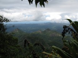
Things took a turn for the worse around the halfway point. First of all, I slipped on a rock and bit it pretty decent trying to get a picture of a blue lobster or crayfish or something. Then, the big lookout we’d come to see was all but grown in and there was almost nothing we could see through the trees. It was beautiful, what we could make out, but it was a tease at best. Basically, we’d walked to the edge of an ancient and massive volcano crater that spread over miles and miles of terrain. In the middle is Mt. Warning, all that remains of the volcanic tube that erupted massively so many millions of years ago, but we couldn’t even see that from our vantage point. Then, Alli discovered there were leaches. The rest of us knew (it was in the pamphlets) but didn’t feel it was in her best interest to tell her. She was miserable for the whole second half of the hike. We couldn’t find a decent place to have lunch, so I found a log that had fallen and we ate there. The second half was just more of the same. Trees and rainforest and no waterfalls or anything to speak of. The price we extracted for the first half of our hike having all those cool massive trees and beautiful falls, I suppose.
We got back and basically had nothing to eat for dinner, really, but I had eaten trail mix on the path so I had my lunch sandwich to munch on had I wanted to. But instead Chris and I went and had a couple beers and I had a bit more trail mix. Ah, roughing it. I finally did eat that sandwich I bought the next morning, at the risk of sounding like I’m writing a diet journal here. We packed up our tents and headed off. Alli ripped one of her contacts the day prior which meant she did the leech-hike half blind and we had to stop off in Nerang to pick up another set for her and her and Kate weren’t feeling tops so they stayed there while Chris and I jetted off. None of us had had a particularly good sleep either night in Lamington, not for any particular reason – except Chris, who was suffering a bit of a cold the second night – we just collectively slept poorly.
So, Chris and I left them in Nerang and took off to scale Mount Warning. The drive out there was beautiful, coming off the mountain ridges that border Queensland and New South Wales and into beautiful New Zealand-esque valleys. It being fall, things are particularly pretty and flowery – not dying, just beautiful. And green. And no, my photos didn’t capture it. Purple trees, green grass, blue skies, and unfortunately, some white and blue clouds around Mt. Warning. We went on anyway, parked, and saw that we had a 4.5 km hike to the top and the mountain itself was 1127 metres high. The rainforest here was a little more sparse and that somehow made it better. It really doesn’t feel real to be here among these plants – I feel like I’m going to turn the corner at any moment and see the line up for the Jurassic Park or Indiana Jones rides in Disneyland/world. The path here was obviously pretty uphill and towards the end we were scrabbling up a steep slope basically on all fours.
On the way up there were a few vantage points where we could see the valley around us and the mountains in the distance that made up the volcanic rim – including the lookout we’d walked so hard to get to only yesterday. At the very top, however, we were enveloped in cloud, which was cool in itself because they were moving around so quickly. We’d get clearings where we could see the ground and valley and other clouds swirling around and everything else, and we basically had the mountain to ourselves. Ourselves and a turkey that attacked Chris’ pack when we were looking on the opposite side of the peak. Luckily, we caught it in time and no damage was done nor garbage strewn. Then, back down just as the rain began. We had to walk the steep peak stretch backwards using the chain to almost rappel but the rest of the walk was uneventful and the rain was neither heavy nor enduring. At the bottom, we met a couple that was really nice and kept giving us places nearby to check out. Specifically, they told us about a watering hole nearby that they thought was great and told us about some local music in a small town called Uki nearby.
We swung by Uki but it looked like it was basically a dj and some guy playing didj so we decided to skip out on that and we decided to come back home instead. We passed a tropical fruit park and thought maybe there’d be something cool there, but alas, closed. However, the people there were freely volunteering another place worth checking out, a natural bridge with a waterfall, glow worms, and apparently now was the time of day to see it. We thanked these incredibly friendly Aussies and drove on to the arch following their directions, stopping to take photos of Mt. Warning in the sunset. At which point we met another friendly Aussie who came out of his house to mention that the place he thought it looked most beautiful was up the road over the bridge where you could see the reflection in the river. Really friendly people, these Aussies. Even if they can’t give directions to save their life. We took the second turn into Condong as instructed and found ourselves driving rural roads in the middle of nowhere. Which was the perfect time to let Chris try driving here in Aus. He did quite well except for the tendancy to drive more left than you would or should. I have the same problem, so I guess it’s a gut feeling coming from driving on the opposite side of the car.
We gave up on finding the arch and grabbed dinner in Murwillumbah before driving on to Surfer’s. We decided to have a guy’s night out and found (after more Lonely Planet cursing) a hostel, showered, and had a bit of wine and nachos (not a recommended combo, incidentally) before heading out. It was a good night out and we got back around 3:30 to our hostel.
We woke up bright and early… or at least I did. I set my alarm for an hour too early again. Which meant just before 5AM instead of 6AM. Since I hit the proverbial hay at 1, it was a little early, but we had a big hike ahead of us, so that kept me moving. We left in nice weather for Tongario National Park, where we were to hike in the shadow of Mount Doom from Lord of the Rings. Well, to really make it feel authentic, the weather got nasty as soon as we came to the edge of Mordor. I got a little confused between the Misty Mountains and Mordor, in other words. The mist was pretty light but we all threw on our waterproof stuff and set off.
The landscape was very sparse, feeling like the Canadian Shield or the northernmost portions of Norway, and we passed the swamp of the dead and lots of desolate volcanic fields, surrounded by, I can only assume, lush green mountains, waterfalls, and hoola girls. All of which were hidden by the mist, which grew heavier and blew harder as we ascended. I spent most of the hike with Anthony, who’s a pretty cool and friendly guy. We were near the back as I was still attempting to get some photos of the misty hike, which was basically being done in black and white – the lava and the mist. We soon found ourselves near the front and then he was gone, off in the lead on his own and trekking like an old pro.
The weather continued degrading, and my supposedly waterproof rain jacket was soaked through and through. My waterproof pants were mercifully holding up, but at the rate that the moisture was increasing, that couldn’t last long, It was a very steep climb and there were a lot of small breaks, and more than one person feeling bad for poor Frodo and Sam as we began to feel more and more tiny and hobbitlike on this vast volcano; shadowy figures on craggy slopes in cloaks on a mission. Except that we gave up and turned back because some of the group was tired and cold, and all of us were wet. To be fair, there wasn’t much use in pressing on as the visibility was continuing to drop and it was sometimes a struggle just to find the next marker. Scrambling down the rocks was even more treacherous, and all of us took a little volcanic mud home as a souvenir, either in our shoes, on our pants, or on our hands. Never content for a small serving, I took all of the above.
We took the van back towards the campsite and enjoyed a brief bit of sun en route before ending up in Mangaweka, our misty campsite. By now, we were really sick of the rain and wet, so setting up a tent in our drenched clothes in the rain was not exactly a picnic. But we got it done and decided that the solution to this wetness was to get really wet. So we walked down to the river and took a swim.
First, I should mention that only half the people were supposed to bring tents and then we were all to share. But, given the ratio of five guys to, well, a lot of girls, this was somewhat awkward. Moreso then it should’ve been – they wanted the tent to themselves and who can blame them, but it left a few of us in the cold for a while. We did finally get spots though, and I slept in Katie’s tent while Anthony, the other guy stuck in this situation with me, wound up with Kristin. Anyway, the campsite is actually pretty nice. It’s in a sandstone canyon, with big cliffs surrounding it and a very quick and fast moving rapids at the base. This is what we were swimming in. We’d walk in carefully until we fell and then let the current take us through the rapids. Not exactly safe, but lots of fun. The rocks would usually hit your feet and sometimes the current would just carry you right up and over the rock and you’d be back in it again. This, coupled with some kiwi-flavoured wine, was exactly the state that Anthony was in as he decided to go down the bigger rapids at the end. The others, Brad and Meridith (and later Chris), didn’t have that excuse.
Anthony and Brad took the rapids and wound up right against the cliff wall. They tried to climb up but Brad lost his footing and slid unceremoniously down into the water to try again, while Anthony made it up a fair distance and then had to turn back. They crossed the river to the other side, walked up a ways, and tried to cross, but got swept back down to try again. Finally, they made it across and joined the camp. Then we had a bit of dinner, and cracked open our bottles of wine. It seems that wine has become the drink of choice for the group, and I’d like to take credit for it. Though in truth, I’m not sure why. I guess we’re all trying to sample fairs from this side of the world.
Brad showed his camping skills by getting our fire going and we had quite a campfire party if I may say. Lauren and Chelsea joined Anthony as the most ‘active’ at the party, dancing like crazy and probably burning more calories than they drank giggling and laughing. Katie was not far behind, especially when they went up to a neighbouring camp and drank some moonshine (which was quite tasty, actually). Dustin drank for the first time on this trip and had enough to merit a late night resurgence next to poor Kristin’s tent. It was a good time and a good bonding experience for everyone. And we forgot about the rain.
The next morning we woke up, had some oatmeal (and more than one cooking mishap), and went kayaking and rafting on the same rapids we’d been body surfing through the day prior. While it was fun to kayak, you can imagine that the river itself was a little dull. It was beautiful and scenic, but nothing like the rafting we’d done only a few days prior. I still enjoyed it of course (how could I not?), and we had a good float. Then, back to the camp to pack up our stuff and off to Wellington, which I understand is our last stop on the north island. Already. It feels like it’s been two weeks and two days all at once. Neither of which is correct, but there you have it.
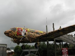
As far as the group goes, I’ve come to appreciate that almost none of them are the stereotypical Americans we all know and loathe, and I feel bad because they’re all good people and undeserving of their sometimes cool reception and are also very accepting and understanding of it. Even self-mocking. They might as well be Canadians! Oh, and en route to Wellington, we passed yet another converted plane. What the New Zealand fascination is with converting planes and posting them on poles as advertising is beyond me. I still have yet to discover that cross constellation that can only be seen from the southern hemisphere, I haven’t encountered a spiraling toilet to observe the Coriolis effect at work, and I’ve seen little in the way of dangerous fauna or animalia. I guess there are other stereotypes that aren’t fair too.