We drove up the winding roads into the green mountains of Lamington National Park quite happily. They were fun roads to drive and it was nice to be in a car doing them. We’d hoped to get groceries and supplies in Cunanbura but there was little there, so instead we had fish and chips at a little chipper and hit the road. We camped just outside of O’Reilly’s famed resort (though I’m not sure why it’s so famous) and there were Wallabees all over the campsite – not to mention more bush turkeys. After deciding to stay for two nights so we could do a full day hike tomorrow, we set up camp and took a hike up to the Python Rock lookout to watch the sunset. It was pretty gorgeous up there and we crawled right out to the ledge and an overhanging rock to view it. It was a little scary but a great view past the trees and over the forest below.
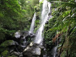
Chris and I went for dinner in the pub, but it was too pricey so I just had soup and we had a beer each and basically called it a night. It was pretty cool out here, which for me was just right. We got drizzled on a bit without our rainfly but nothing worth getting up to put it on and I finally gave up trying to sleep at about 6:30. Not the best sleep ever, and the others said the same. We set off as soon as the café opened at 9AM so we could grab some sandwiches for lunch there and took the Toolona Gorge trail, a 17.5 km trail that takes us to the New South Wales border and along a couple waterfalls. It started out pretty decent; there were a few waterfalls, we were deep in the rainforest, and we took a treetop walk which, at one point, had us 30m above the ground. A little scary to be that high up in a tree, to be honest, but obviously it was quite safe on those bridges and up the tree.
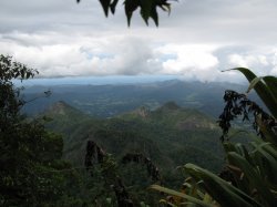
Things took a turn for the worse around the halfway point. First of all, I slipped on a rock and bit it pretty decent trying to get a picture of a blue lobster or crayfish or something. Then, the big lookout we’d come to see was all but grown in and there was almost nothing we could see through the trees. It was beautiful, what we could make out, but it was a tease at best. Basically, we’d walked to the edge of an ancient and massive volcano crater that spread over miles and miles of terrain. In the middle is Mt. Warning, all that remains of the volcanic tube that erupted massively so many millions of years ago, but we couldn’t even see that from our vantage point. Then, Alli discovered there were leaches. The rest of us knew (it was in the pamphlets) but didn’t feel it was in her best interest to tell her. She was miserable for the whole second half of the hike. We couldn’t find a decent place to have lunch, so I found a log that had fallen and we ate there. The second half was just more of the same. Trees and rainforest and no waterfalls or anything to speak of. The price we extracted for the first half of our hike having all those cool massive trees and beautiful falls, I suppose.
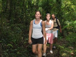
We got back and basically had nothing to eat for dinner, really, but I had eaten trail mix on the path so I had my lunch sandwich to munch on had I wanted to. But instead Chris and I went and had a couple beers and I had a bit more trail mix. Ah, roughing it. I finally did eat that sandwich I bought the next morning, at the risk of sounding like I’m writing a diet journal here. We packed up our tents and headed off. Alli ripped one of her contacts the day prior which meant she did the leech-hike half blind and we had to stop off in Nerang to pick up another set for her and her and Kate weren’t feeling tops so they stayed there while Chris and I jetted off. None of us had had a particularly good sleep either night in Lamington, not for any particular reason – except Chris, who was suffering a bit of a cold the second night – we just collectively slept poorly.
So, Chris and I left them in Nerang and took off to scale Mount Warning. The drive out there was beautiful, coming off the mountain ridges that border Queensland and New South Wales and into beautiful New Zealand-esque valleys. It being fall, things are particularly pretty and flowery – not dying, just beautiful. And green. And no, my photos didn’t capture it. Purple trees, green grass, blue skies, and unfortunately, some white and blue clouds around Mt. Warning. We went on anyway, parked, and saw that we had a 4.5 km hike to the top and the mountain itself was 1127 metres high. The rainforest here was a little more sparse and that somehow made it better. It really doesn’t feel real to be here among these plants – I feel like I’m going to turn the corner at any moment and see the line up for the Jurassic Park or Indiana Jones rides in Disneyland/world. The path here was obviously pretty uphill and towards the end we were scrabbling up a steep slope basically on all fours.
On the way up there were a few vantage points where we could see the valley around us and the mountains in the distance that made up the volcanic rim – including the lookout we’d walked so hard to get to only yesterday. At the very top, however, we were enveloped in cloud, which was cool in itself because they were moving around so quickly. We’d get clearings where we could see the ground and valley and other clouds swirling around and everything else, and we basically had the mountain to ourselves. Ourselves and a turkey that attacked Chris’ pack when we were looking on the opposite side of the peak. Luckily, we caught it in time and no damage was done nor garbage strewn. Then, back down just as the rain began. We had to walk the steep peak stretch backwards using the chain to almost rappel but the rest of the walk was uneventful and the rain was neither heavy nor enduring. At the bottom, we met a couple that was really nice and kept giving us places nearby to check out. Specifically, they told us about a watering hole nearby that they thought was great and told us about some local music in a small town called Uki nearby.
We swung by Uki but it looked like it was basically a dj and some guy playing didj so we decided to skip out on that and we decided to come back home instead. We passed a tropical fruit park and thought maybe there’d be something cool there, but alas, closed. However, the people there were freely volunteering another place worth checking out, a natural bridge with a waterfall, glow worms, and apparently now was the time of day to see it. We thanked these incredibly friendly Aussies and drove on to the arch following their directions, stopping to take photos of Mt. Warning in the sunset. At which point we met another friendly Aussie who came out of his house to mention that the place he thought it looked most beautiful was up the road over the bridge where you could see the reflection in the river. Really friendly people, these Aussies. Even if they can’t give directions to save their life. We took the second turn into Condong as instructed and found ourselves driving rural roads in the middle of nowhere. Which was the perfect time to let Chris try driving here in Aus. He did quite well except for the tendancy to drive more left than you would or should. I have the same problem, so I guess it’s a gut feeling coming from driving on the opposite side of the car.
We gave up on finding the arch and grabbed dinner in Murwillumbah before driving on to Surfer’s. We decided to have a guy’s night out and found (after more Lonely Planet cursing) a hostel, showered, and had a bit of wine and nachos (not a recommended combo, incidentally) before heading out. It was a good night out and we got back around 3:30 to our hostel.


No comments:
Post a Comment