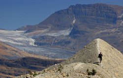
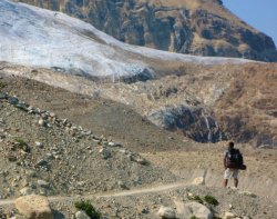
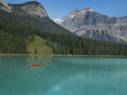
The waning days of the Canadian expedition were upon us. We studied the maps, looking over our options. The Kootenays had a pretty nice hike along a ridge, though that meant 180 degrees of rock wall. Banff didn't seem to have any very exciting hikes without getting into multi-day treks we lacked time for. And Yoho had the Iceline Trail which seemed a good way to get in some alpine meadows, glaciers, waterfalls, and exercise all at the same time. So we set sail for Yoho early in the morning, encountering the Spiral Tunnels on the way there. These are a series of tunnels in the mountain that essentially spiral down gradually so that the trains can lose or gain elevation without a steep grade. Many trains and lives had been lost on this stretch before turning to the Swiss for a solution and since the 30s it's been working beautifully. As we watched the train reappear above itself and the front of the train cross over the back, we didn't realize we'd be wishing for a similar device on the Iceline trail later that very day.
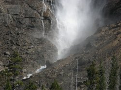
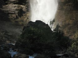
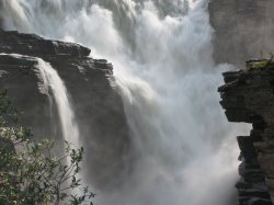
After arriving in the parking area for Yoho and fixing lunch, it was time to see off. The first stop was Takakkaw Falls, Cree for Magnificent, and that it was. At around noon it was a good time for photographs and Dan and I spent some serious time with our cameras putting off the hike. And then the Iceline Trail was upon us. Most people do not do the trek in the way that we were setting out. Going to Little Yoho via the Iceline Trail meant a very steep ascent to the mountain tops and then an undulating ridge walk before a moderate descent. In contrast, the lower path allows a first day (fully laden, by the way, with all the food) of gradual climb in the shade of the valley floor to the campground at Little Yoho followed by a second day with a moderate ascent and a steep descent. Makes a lot more sense, yes, but for the sake of lighting in our photos we went the path less travelled.
Unfortunately, it didn't make much difference. The skies were hazy from BC Forest Fires which eliminated any great panoramic vistas we may have captured. Additionally, a lot of what we wanted to capture was actually UP the ridge rather than down, meaning we'd timed our hike all wrong. Nevertheless, it was a beautiful hike along what felt like dozens of glaciers at a high altitude in great weather. Not so great for hiking with 20 kilos on our backs, but great in that it was sunny, hot, and aside from the haze, clear skies. We were frustrated repeatedly by inaccurate trail markings, almost all in blatant contradiction to our map which had deficiencies all its own. How this is possible in the age of GPS is beyond me, but this has been a recurring and embarassing theme throughout the national and provincial parks we visited. Nevertheless, while demoralizing to our ego (it only said 5 km, it HAS to be over THIS ridge) we did eventually arrive, 11km later, in Little Yoho.
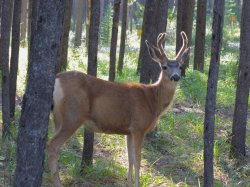
The campsite was nice and we met some cool people travelling from all over the place, but as the sun went down fatigue overtook us and we were out like the proverbial light. The next morning I woke up earlier than Dan and got coffee, tea, and breakfast going. After a hearty bowl of oatmeal and bananas we pulled up stakes and hiked back out the lower trail, 9km, past Laughing Falls and one of the highlights of the trip. A biiiig black bear, in the woods, no more than 20m from us. Dan heard the crack and held his hand for a stop and we stood listening and looking into the shadows until the shadows moved. I started to open my camera case and Dan looked at me sharply. "What are you doing?!" he asked. "Getting my camera," I impertinently whispered back. It was a waste of time perhaps, but it could have also been an excellent shot. The bear inched towards us and we backed away. It ventured further and we took our leave. But at last, in the middle of the forest, no roads in sight, and we had seen a wild bear. Yoho had delivered what every other park (aside from Jasper, which compromised with a cub near the roadside) failed to deliver.
From Yoho, we stopped at our old campground in Lake Louise for a quick shower then drove up to Banff, picked up a few groceries for today and tomorrow, and set up our camp, unfortunately, at the camp far out of town. It was huge and it was absolutely empty. We basically had 1500 campsites to ourselves. Or at least at first. We did get some neighbours, including a creepy old man with a van that looked like it might have been an accessory to various crimes over the years. Did I consider sleeping with a knife? Yes. But we slept and awoke alive as you may have guessed, with nary a blood-curdling scream the whole night. It was now August 30, the last day. In fact, I was flying home that evening at 9 PM. So we had a pretty relaxed last day. We walked to, and up, Sundance Canyon which was more of a stroll than a hike. And we enjoyed the end-of-summer warmth by relaxing alongside a nice and quiet lake (the name of which I don't remember) while in the car, Dan's computers burnt my photos onto DVDs.
Returning to the city was mostly a relief. It had been a great two weeks, we'd gotten a lot of exercise, seen a lot of beautiful places in Canada, and lived a pretty simple life. It was a great time. But I was happy to be back to civilization, to know that I would be sleeping indoors for the first time in two weeks, with all the comforts of home. As great as it was, we kept up a pretty hectic pace and I was ready for a little sedentary activity. Dan and I went for some pasta at a restaurant near the airport and said our farewells. He was off to the border for Glacier National Park, and I was on a plane for Saskatoon. That is, after a little time in the Chinook Lounge enjoying the sunset, a bag of chips, and the better part of a bottle of wine. Night fell, and outside the garish orange light of the city a vast wilderness awaited.
It was nice to be home. Sept 1 was my birthday and I had a few quiet drinks with some friends after going out to dinner with the family. Sept 3, Franz Ferdinand was in town, and I attended with John, Leona, Kirk, Darren, and Larissa, forced to sell my last two tickets because I don't have enough friends with good taste in music. Too bad, because it was amazing. Such a great show! But ridiculously hot, standing outside after when it was still 25 Celsius, the open doors felt literally like an oven, people escaping drenched in sweat. Larissa soon after left for Mexico again, to work in a resort and probably more importantly visit Julio. And the rest of September and October disappeared in a blur as I prepared for the next big trip: half a year in Central and South America. Leaving October 28.
Canada’s a big country. And if I may be so bold to say, it’s a beautiful country. So for a road between two places to be considered a must-do in this country, well, that’s quite a big deal. For it to be consistently considered one of the top 10 drives in the world, well, frankly, it’s a little difficult to swallow. It’s a big world out there and I like to think that I’ve seen a fair amount of it. Notable drives for me are the road to Andalsnes and beyond to the fjords in Norway, the road to Vang Vieng from Luang Prabang in Laos, the cobblestone silk road from Shangri-La towards Tibet in China, the dirt and sand 4-wheel-only Gibb River Rd through the Kimberly of Australia, and while the Great Ocean Road is an obvious choice from that country, I’d nominate the road south of Kalbarri over top of it. This is some tough competition and as much as I’ve travelled, I haven’t scratched the surface of the globe yet. So tough to swallow, yes, but then you consider the beauty of Banff and my newly discovered appreciate for the splendours of Jasper. And you think that this is a road that connects these two great parks along the spine of the Rockies, passing glaciers, azure rivers, mirror lakes, and waterfalls and you realize that not only is it possible... it’s downright obvious.
And better still, it’s on the agenda. As a very plump cherry on top of this proverbial cake, the weather was perfect. Simply perfect, and this coming from Dan, who hates a clear blue sky because it makes his photos too boring. It was a warm mountain morning, the clouds from last night were breaking apart and going their separate ways, and we were on the road again. I won’t bore you with every single detail, but if there was a place to stop on the way, we would. It was as simple as that. There were certainly places along the way we never hiked in order to take advantage of this day and see the road in its entirety, but we stopped and considered every time. No serious hikes today, however. It was all road. The road itself was photo worthy. It climbed inexorably up, only to plummet down equally fast. It came around in large loops and switchbacks, so that you could see it wind its way down from you and cut along the valley floor like the contrail of a jet engine. It crossed rivers, came all but right past the bottom of the Athabasca glacier, endured metres upon metres of snowfall (in other seasons) and still here it lay, a thin ribbon of civilization. Which is the reason that several of my photos (including one of my favourites – a panorama of the North Saskatchewan River) include or even focus on the road. In case you were wondering.
We stopped many times along the way, many many times. Sometimes it was to look at (or photograph) distant mountains or waterfalls, sometimes for a hike and sometimes just for a little photographic leg stretch. The landmark site on this trail is without a doubt the Athabasca glacier. My grandpa remembers it coming right to the highway but it is nowhere near anymore. Even having receded well back into the mountains, it is still grand, flat, and – although they discourage it – walkable. We parked, had lunch, and then set out up the glacier. There are definitely cracks, and I won’t deny a little unease at crossing near them or even near the small melt streams that amble down the glacier’s face, but plenty of people were walking around and taking their chances aside from us, and both Dan and I have done some glacier hikes in the past. All told, we were probably on that glacier for two hours and it was beautiful. The melt streams I mentioned glowed an iridescent blue, almost unbelievably. As we climbed higher the air blowing over the ice grew cooler but the sun was shining and it was a perfect day for not only our drive but also our climb. The view across that valley was beautiful but hard to capture and soon we were farther along than even the guided groups were venturing and it was time to turn back. But not before some silly photos attempting to look cool and jumping across melt streams.
The second highlight, was crossing the North Saskatchewan River at Saskatchewan Crossing. The colour was like any other river in this part of the world: spectacular. By the time it comes through our neck of the woods, it is a dark blue but here it practically glowed. It somehow made me appreciate the great water we have back home (even though it is the South Saskatchewan that flows through Saskatoon) to see it here in pristine and untouched form. I also managed to get one of my favourite photos on the entire Canadian Expedition right here on this bridge. You’ll have to trust me that it looks great at full size. We also had a lot of fun stopping along the lakes and vying for the best photo, a contest I may have been doomed to lose from the beginning. To be fair, I did initiate the inclusive of the purple flowers into the photo, but Dan had the best technique and he got a great photo of one of the lakes with distant mountains reflecting and of course purple flowers in the fore.
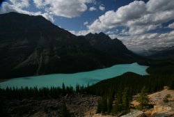
And the final highlight caps the Icefields Parkway on the southern side: Peyto Lake. Named after “Wild” Bill Peyto (you probably remember the saloon named after him in Banff), this lake is probably the nicest among scores of world class lakes on the drive. We parked, made our way, waited for the tour bus of people to disperse, then hopped the fence to get some good photos. A German woman called out “Excuse me!” which Dan didn’t hear (though I did). Then “we’d like to take a photo,” to which Dan replied, “I’ll just be a minute”. At this point her husband piped up, “We’ve been here already for 10 minutes” and Dan, “No you haven’t. WE haven’t been here for 10 minutes” “Well, maybe five minutes” the man replied, but he’d already lost. Now, this isn’t a confrontation I’d like to have, and I definitely can appreciate wanting people out of your photo, but it seemed they were going a bit far. Dan’s responses were rude and I felt embarrassed, but then they were pretty rude to begin with. Why is their photo more important? We really had only been there for about two minutes and I’d already gotten out of the way behind a tree for their benefit. The more I thought about it, the more it was just kind of funny.
Anyway, we got our photo of Peyto Lake, though the light wasn’t ideal it was still pretty nice. Still, Dan wanted to come back in the morning for another photo and I was up for it. We had now entered Banff National Park, incidentally, and we found a nice campsite in Lake Louise then came back the next morning. I was shocked at how much more beautiful this lake looked lit from a different angle. In fact, I was shocked it could even look better than it had the day prior, but here was evidence. You can be the judge, too. From Peyto Lake, we drove down to Bow Lake to look around and then to Lake Louise. I had to the overpass many a time, turning to go ski the slopes at LL, but only once before had I been to the actual lakeside, when I was very young. I don’t really remember it even, but I have seen photos. So it had a sort-of familiarity that probably wasn’t merited but there it was.
We set out from the hotel at the base of LL to hike to the glacier that backs it, specifically The Plain of the Six Glaciers trail. It takes you along the edge of the lake and then up into the mountains for, you guessed it, a view of six glaciers up there (though I only saw five). There’s also a teahouse up there for anybody looking for an excuse to exercise that doesn’t involve scenery or photography, but we didn’t stay for tea. We had another walk to Mirror Lake off the upper trail back, so we didn’t have to double back on our trail. All said, it was 16 km on top of some early morning photography. The trail was nice and the hike was worth it, though next time I’m going to have some mountaintop tea. Maybe because it was tradition in Asia, maybe because I like the idea of doing something patently out of context on a mountaintop, like sipping tea, I’m not sure. But it felt wrong to skip it.
Our third day brought us to something that Dan had been looking forward to since the airport in Vancouver – Morraine Lake. In fact, I think that a friend’s photos of Morraine Lake are what brought Dan up to Canada in the first place. We caught Lake Louise at sunrise and were at Morraine Lake to take photos for the golden hour, which in this particular location’s case, was 10 or 11. Climbing up to the vantage point I took the unfortunate path of walking across logs in shallow water, not realizing until too late there had to be a better way. Which was right when I slipped in. I sloshed my way to the top of the rock pile that gives Morraine Lake its name and there was the million dollar view. Or should I say twenty dollar view – the view spread out in front of me is one that I’ve seen many (well, not as many times as I’d like) times before: on the back of our old $20 bill. A solid hour of scrambling and attempting different photos while trying to dry my socks and shoes and having a snack later, we were back at ground level and setting out on our next hike: a three hike combo of Larch Valley / Sentinel Pass / Paradise Valley.
The hike would take us over the back of Morraine Lake through an alpine larch valley (appropriately named, you see) to Sentinel Pass, which rose between two mountains and featured tall stalagmite-like pillars of stone rising like guards (or sentinels, if you will) watching both valleys. From there it was a scramble down some pretty loose scree to Paradise Valley which, to be honest, was a rather boring hike with a few nice spots spread way too far out and guideposts that displayed random numbers of kilometres. The whole deal was 17 km and we had to hitchhike back to the base of Morraine Lake. Well, by we I mean one of us (it’s scary to pick up one person much less two). Dan tried first and was on his last car before it was my turn when some people pulled over and drove him down the road where we were parked. Dan picked me up, again, and our last day was concluded. Tomorrow, we were crossing back into BC to visit Yoho National Park, then back to Banff for a day before it was time for me to get home and Dan back to the States.
In spite of the fact that I live only six or seven hours from Jasper, I have never spent any time in this national park. I drove through it once upon a time on the scenic road to Victoria, I think in 1995 or 1996. I remember wanting to drive because everybody was tired except me. But that’s irrelevant. Dan and I were here, now, and it was our plan to explore the park thoroughly. After stopping at the park ranger’s office for tips, we decided to hike Geraldine Lakes. We drove south towards them, the weather growing increasingly cloudy as we made our way there. After climbing a windy logging road, we set off but did not get very far before the rain started. We’d reached the first lake, about 3 km and decided to press on. With every step, the rain grew heavier, the rocks more slippery, but still we trudged. There was a loud crack and lightning lit the sky and that’s when it happened.
We decided to turn back. I hate to turn back, to give up, but it made little sense to continue. We could see up to the area we’d be climbing to reach the second and supposedly more beautiful Geraldine Lake and it appeared to be the epicentre of this storm. We turned around and hiked the other 3km back to the car. Nature: 1. Man: 0. Looking north towards Jasper town, the sky appeared clearer, so we backtracked to Mt. Edith Cavell, which was a pair of glaciers, one melting with icebergs in the melt pool, the other dripping more traditionally from countless pores into small streams, waterfalls, and rivers. We hiked the trail down to the melt pool and took a look around before we decided to scale the massive scree pile and see what we could see. Now, on a nice day this would be a great vantage point. All we could see was the storm clouds we’d outrun earlier come hunting like Black Riders in Hobbiton, sneaking but determined up the valley, shrieking with every lightning bolt at our prior escape. We got back to the car just as the rain began.
At this point we gave up on hiking for a day and wandered the streets of Jasper. While Dan was talking to a friend on Skype, I wandered around a bit, settling on an old steam train set up outside the train station. It was pristine and had that certain mechanical romance that only the more simple machines of that era can hold and nearby there was an interview going on. When I got home, I discovered that my grandpa had been the engineer for this train, at least for a time, and that was just sort of a surreal discovery. Eventually Dan finished on the phone and another restaurant meal was not in the cards. We popped by the grocery store and picked up a whole chicken and threw it into a stew with corn, beans, rice, and potatoes. It was hearty, hot, and declicious and we only managed to finish half of it which meant we’d have a nice lunch for tomorrow.
That next day was a monumental day. First of all, I discovered why people often rate Jasper higher than Banff. The weather was better and there were too many options to count for outdoor activity. We drove to Maligne Canyon, itself a beautiful drive, and that brings me to the second reason the day was monumental. I spotted my first bear in the wild. Sort of. It felt like a bit of a cop out to see it along the road, but we came across a cub foraging and chowing down on berries along the Maligne River. It was safely distant but we were on the lookout for a mama bear nonetheless. And finally, the canyon itself was pretty nice, though touristy, but using Dan’s tripod I got a pretty cool shot of these two waterfalls within it. We also drove to Maligne Lake, which drains underground into the canyon, and this late in the year, had almost entirely drained itself.
The Malignes (French for wicked, by the way) were nice enough, but they didn’t compare to other things we’d seen. Then we drove south again, stopping first north of Jasper at Pyramid Lake, which was actually very nice, and then at Five Lakes. We hiked in and came across a slough where, according to the map (which in typical Parks Canada fashion was terrible), there was supposed to be one of the five lakes. We climbed a hill and no other lakes were there to be found. So we backtracked away, assuming that like Maligne they’d dried up, though deep down we both felt it quite possible we were wrong and hadn’t reached them yet. We considered telling a family walking down with fishing rods that there was none to be done but thought better of it. We may be wrong, there may have been lakes, and we also faced the danger of bursting out laughing.
The last stop for the day was the lovely Horseshoe Lake, seemingly abandoned except for some locals, this pristine lake has great spots for cliff jumping and all around was a pretty nice place to hang out. We weren’t prepared for the cliff jumping but we did hang out and watch others and with the sun beaming down it was a nice spot. Certainly, if Five Lakes had been anything like this we would have probably stayed there. But we weren’t going to be staying anywhere for too long. After all, I had to be home for the beginning of September, a Franz Ferdinand concert, and my birthday. It was my last one in the 20’s after all. So the next day, Dan and I set off south towards Banff. This is no routine drive, it is regularly rated one of the best drives in the world and you can see why. Next time, on The Life of I.
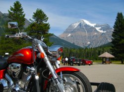
It’s easy to get into a routine of waking up early when your days are spent doing physically demanding activities and you live in a tent where the light is gone by 9 and the sun is up by 5. So contrary to my normal modus operandi, waking up at 5:30 was not a problem. After the ritual morning coffee for Dan and tea for me, followed by breakfast, we packed up and made our way to Mt Robson, the tallest mountain in the Canadian Rockies and home to some excellent hikes. Or so we’d heard. Of course, you can only see the top of this mountain – which is so big that it creates its own weather system – maybe 14 days of te year. The rest, it is shrouded in cloud. This was one of those 14 days and we were both awed and grateful to see this massive mountain in its entirety. We were less excited to discover that the campground we wanted was booked up so we wouldn’t make it too far that day. We did however get a camp spot 11 km in at Whitehorn, which was definitely a step or several thousand in the right direction.
While we were packing up our gear for the hike, any number of German and Japanese tourists came to have their photo with the bike. By the time we did set off, after a quick lunch at the car, it was 1:30. You start by crossing a river, hiking for some time in the forest and then eventually coming to a lake which you follow along to a river that winds around the mountain. Our trek to Whitehorn was pretty relaxed as we didn’t have a lot of distance but we did have plenty of time. We stopped and de-swelled our feet in the glacial river before getting to camp. These camps were supposed to have bear poles to hang your food out of reach of the bears, but it did not – simply bear boxes that were, you hoped, impenetrable. We ate and got some rest, for tomorrow was going to be a bigger day than either of us had planned and we’d need all the energy we could muster.
We had booked a second night of camping in at Berg Lake, thinking we could easily cover the distance on our third day back out. However, we woke up to a beautiful day and after some discussion decided to leave our tent setup and hope nobody needed the spot. This bumped our 14km day up to a 30km day and we needed to get moving. As we went along the trail the weather started to get cloudy and we heard from others that there was a risk of thunderstorm for which we were not really prepared. Still we pressed on as things didn’t seem likely to go that way in the next while and we were coming up on some great waterfalls. Particularly, Emperor Falls was awesome. The first view you get from afar is the waterfall with the sun tinting the mists golden. It falls into a trough cut impossibly midway across a vertical cliff face, so that the river runs like an aqueduct far above the valley floor. It is surreal and difficult to capture in words or photograph.
From there you wind your way closer, near to the very base of the waterfall. Dan and I weren’t satisfied with near and made our way to the roaring base, As many views as we’d been afforded of the waterfall from afar, nothing could prepare us for the immensity and power of the waterfall. We took some silhouette photos slightly above the base of the falls, getting thoroughly drenched in the process and then proceeded up the steepest part of the entire trail. It was a relief to get to the top of that and finally meander our way to Berg Lake. Here again was another place that had it all. Waterfalls, glacial blue lakes, the tallest mountain in the Rockies, glaciers, snow, and sun.
The sun, however, was fading and haze from nearby forest fires rolling in, which did not bode well for our photography. Still, we pressed on, taking the upper track to Mumm Basin which gave great views of yet another glacier in the distance, the mountainside, the valley, and of course Mt Robson though it was now clouded over. At that altitude, though, the wind was heavy and brisk and we got a bit of rain as well as we made our way to Toboggan Falls, a waterfall that runs like water on an immense slope rather than carving a drop as most falls do. This was our landmark to head down to the lower trail and lose the 1 km or so we’d gained in elevation. We stopped at Berg Lake where we were to have camped and had a lunch of rice, ichiban with canned turkey and a granola bar before setting out to return to our camp. We made it back exhausted, physically and mentally drained, reaching shelter less than a minute before it suddenly began to pour and the thunderstorm rolled up the valley. It was a great day to be alive.
The advantage of hiking all the way back to our starting point, aside from not having to haul alot of the equipment, was that we were only 11km from the exit. We hiked out and crossed the border in Alberta and specifically Jasper National Park where we set up an early camp and celebrated our heretofore hectic pace with beer and pizza at a little restaurant nearby. I’d never really spent any time in Jasper, I didn’t like the town itself as much as Banff right away, but I would discover that it offered far more outdoor adventure than Banff during the summer months. And, dare I say, my first encounter with a bear in the wild? Next time...
In Singapore, March 2008, I met a man known to many as Alabama Dan. We were both working on our photos and had just come from Indonesia, he from Sumatra and I from Java and inevitably began comparing notes. We went for beer later with a couple girls and further down the road met up again in Luang Prabang, Laos and stayed in touch as we both worked to get our Chinese visas. While I went home in August of the year, “Alabama” Dan Fritts kept on travelling, hiking in Nepal to Everest base camp, riding across Mongolia, heading to Egypt, Jordan, and then home. But coming home for him was simply a springboard to the next phase of his worldwide trip: The American Expedition. From afar he nagged me to join part of his journey. Photos of canyons in Zion, Utah; Volcano climbs and beach camps in Hawaii; Skiing the slopes in Colorado; A few weeks in Guatemala; I almost joined him on each of the latter two. Pictures would come my way, stories here and there, Facebook status updates, all means of persuasion. And finally, when he said he was coming up to Canada and heading to Alaska, I caved. Although we didn’t end up in Alaska due to the expense, a “Canadian Expedition” was planned from Vancouver to Calgary through the mountains hiking our way east and, for me, home.
The flight left Saskatoon August 17 at a bleary 6:10 AM and after finally falling asleep at 2 AM, I almost slept in. Thankfully, dad woke me up at 5:00 and I was packed and ready to go, so I simply had to get dressed, throw my backpack on my shoulders, and walk out the door. My dad had even gone to the trouble to make breakfast for me, cutting up some fruit and snacks for the plane ride. What can I say? I’m pretty lucky. On top of this, when I arrived in YVR and stepped outside and into Dan’s green pathfinder (with an awesome motorcycle on the trailer), he also had some breakfast waiting. We caught up on the drive through Vancouver north towards Whistler and more specifically towards Garibaldi Provincial Park. Three hours of sleep or not, we had a 9 kilometre hike ahead of us up and down a mountain to reach Garibaldi lake and the glacier that feeds it. Uphill was a bit rough on me, being both tired and somewhat out of shape, and I forgot my camera in the car which I thankfully discovered on our first kilometre and ran back to rectify. Not the smoothest start to two weeks of outdoor adventure.
Aside from that little snafu and the almost-sleeping-in however, everything went fine. After a seemingly interminable uphill slog we could glimpse that indescribable blue of the glacier lake through the trees below us. And then we began descending, finally reaching a clearing downstream on the Garibaldi River and giving us our first view up the river to the lake. The colour was nothing short of incredible and though in this age of cynicism everything beautiful has been photoshopped, I can tell you that I did not touch the colours or do much more than a little cropping here. Even had I wanted to, I don’t know what could be done to improve them, even if they fail to do justice to the spectacle in real life. We hiked the rest of the way to the lakeshore and set up camp and after looking around a bit and getting some photos we cooked up a sausage spaghetti primavera. Not bad for being in the wilderness, not bad at all.
The sun was beginning to set on Garibaldi which burned up our digital film with each minute change in shade. It was a perfect sunset in a perfect setting, the glacier ahead absorbing colour from the sky like ink on a white dress. It probably got a bit chilly in the evening but I don’t remember, I was so tired that I pretty much passed out instantly. That sleep was needed and then some, for the second day brought 24 km of ground to cover on foot, hiking up to the top of the Panorama Ridge which affords amazing views of the lake and glaciers below, the mountains distant, and the Black Tusk, an ominous looking spire of obsidian clawing at the sky. And we couldn’t have asked for a better day to do this hike. The weather was perfect, the skies clear, and the sun shining, and we set off again, up and up to the Panorama Ridge.
On the way, our eyes were peeled for bears. It is a sad Canadian that has not seen a bear in the wild, and I was tragically a member of this oft-scorned club. I was hoping to remedy this. No bears were spotted, but I did see two marmots, which was also a first for me. Soon we were at the top and it was better than I could have expected, bordering precipitously on perfection. I had reception on my iPhone and even photos taken from its poor camera had received plenty of praise by the time we finished hiking out. Our main goal complete, and a quick lunch of apples and peanut-butter sandwiches, we set off for civilization again, making pretty good time in the mountains at about 5 km / hr. Even when we’d reached the vehicle again, there was still plenty of ground to cover. There weren’t any really significant stops for some miles.
We stopped in Whistler, as I’d never been, and looked for a cheap place to grab a bite while we explored the small town. I didn’t realize that they used the mountains for mountain biking in the summer, this was a revelation that I found very exciting. Dan was meanwhile impressed by the sheer number of people using the lift, particularly those with high-end gear. I think that had we more time and money a day on the mountain here would’ve been in order. Instead we returned to the car and set off north towards Jasper. There was no time for cooking so we stopped for some pizza in Pemberton which, somehow, felt very familiar to me. I think I’ve seen a photo of my mom at the Pemberton train station before. At 10 we finally came to a recreation area where we pulled in, made camp, and called it another very long day.
Although we had been looking for somewhere to stop along the way, very little presented itself to us that next day. We took the road less-travelled and headed north to 100 Mile House on the old gold trail before turning east. I’m sure both of us will find ourselves on the southern highway again at some point, but up here, excuses are harder to find. We cut across the northern country and skirted some fires nearby enough to darken the sky, making our way for Wells Gray National Park. Thanks to the distance we had covered yesterday, we made it there early enough in the afternoon to drive and see some waterfalls. They were beautiful to look at, particularly Dawson Falls (I think that was its name) a wide, terraced fall. There were others that could have been captured in different light but it was not meant to be today. We debated coming back for some sunset photos but driving and hiking and, in my case, a lack of sleep precluded that. We instead had pork tenderloin for dinner while pouring over the maps, planning the next few days, grabbing a shower, and roasting marshmallows while admiring the impressive array of stars. Tomorrow, we would head to Mt Robson, sitting on the edge of BC and Alberta and boasting the tallest mountain in Canada’s Rockies.
After an action-packed January including Vegas, Chicago, and Mexico, the rest of the winter was Canada as normal. Maybe a bit colder than normal, or so it seemed. There is little to report here because, first of all, as I write this it’s nearly a year later, and secondly, little of lasting interest (that I can remember) happened. I worked, probably went out a few times, saw some movies (what was even playing back then?) and so forth. All the while, Alabama Dan, aka Dan Fritts, a friend I’d travelled with in Singapore and Luang Prabang, was urging me to join his American Expedition, crisscrossing his homeland in search of adventure. I’m not going to tell you it wasn’t tempting, jealousy evoking, or any of that. I just couldn’t get away at that point. The latest request had been Hawaii, where he’d found a very cheap fare (from LA) and planned to do some volcano hiking and beach camping with Rich, his English travel buddy. Though I definitely couldn’t afford that, he floated the idea of going down to Guatemala for more of what I just described in Hawaii.
Even before I came back, I knew that my next trip – and one I’d like to do as soon as possible for age and life sorts of reasons – was going to be to Central and/or South America. When you travel you invariably run into people who have done cooler things than you in places you’ve never heard of. In Australia, that was Southeast Asia . And in Asia, it was South America. And to a lesser extent, Nepal, but let’s not get sidetracked here. The trip to Guatemala was very tempting indeed, except, again that I wanted to do more of the area than one country, but it was a way to perhaps go now. What stopped me from doing this was the prohibitive flight costs from Canada. The day before I would have left to meet Dan and Rich in Guatemala, I discovered that it hadn’t stopped a friend of mine. Megan and Brin, both of whom had also done Australia at the same time as me, were heading down to Guatemala for one month on precisely the day I would’ve been, having discovered a cheap flight. Talk about a small world.
As photos came back from Megan and Dan, I got a bit more excited to make my way into this part of the world. Not to mention that Larissa was working down there and fluent in Spanish, something I was very jealous of. Gears began to turn, but money meant I wouldn’t be able for some time. Luckily, I had picked up Warren Buffet’s biography on a whim and finished it in Mexico. As I read more related works (the Intelligent Investor and then Ben Graham’s Securities Analysis) through the dull winter, his philosophy seemed to crystallize in my mind. It was so clear, so patently obvious, and so at odds with the voodoo spouted by most in that business and I couldn’t put the books down. Moreover, the timing was perfect. The economy, according to all sources, was spiralling down endlessly, perhaps irretrievably. I think some people thought the world was going to end. Certainly, it wasn’t pretty. It’s now November and it’s still pretty shaky. But value is value and with a solid balance sheet and assets, an important company today should, when the smoke clears, be important tomorrow. By March, I’d found the companies I was to invest in – in fact, I found more that were so undervalued as to be almost risk free than I could afford. So I did what any brash and arrogant young man might do. I borrowed from the bank and invested in these gold mines (well, actually mostly copper mines) I’d found.
My selections were educated, my timing was simply plain lucky. As the stocks grew towards what their actual value, as I estimated it, was, the major hurdle to a southern sojourn was lifted. Which, it now occurs to me, is a funny expression because lifting a hurdle would make it harder to jump over. In the meantime, I did do other things besides working and reading company reports at home. A few live acts that came to town included Said the Whale, an excellent Vancouver band that I really love accompanied by The Zolas, whom I also thoroughly enjoyed and later discovered employed the pianist from Lotus Child. That was a great show. Xavier Rudd, Australian didgeridoo dynamo was in town and though he was excellent, the highlight may have been our bartender, Gavin Labelle, doing the worm across stage, telling the opening act (with long hair covering his eyes) to “Let his face be known”, and later recalling his antics at Athena. Jason Webley, a sort of one-man Gogol Bordello, and others came, left their marks, and left.
Winter eventually did the same, and spring quickly turned to summer, though a very windy and cloudy one. Meanwhile, I’d promised Dan I’d take a trip with him even as I knew that before the year was out, probably in September or October, I’d be beginning a trip to South America. As the summer months disappeared all too quickly in the heaps of activities, from golf to soccer to biking the river trails, time was running out and talk was of Alaska. That decided it. I would do Alaska because I’ve always wanted to get that far north, moreso in Canada, but Alaska would do. Plus I’d just watched a documentary on Denali and was very excited. As we researched it more, however, the costs were too great and we had to come up with an alternate. He was going to be on Vancouver Island anyway so that alternative didn’t take long to become apparent. We would journey together from Vancouver to Calgary, stopping at any and every interesting place along the way for hiking, photos, and we would do it as cheaply as possible. This was a plan I could get behind. As summer was threatening to disappear without ever having really come, I booked my flight to Vancouver for August 17. I would accompany Dan through most of the Canadian portion of his American expedition, crossing the mountains from Vancouver to Calgary. This was after my sisters and I packed up the car and drove out to Edmonton for two days and one night at West Ed, for good times, shopping, and waterslides. And it was after an as-always great Folkfest weekend with lots of volunteering, ouzo, and dancing. And, unfortunately, it was before our final soccer game, which I had to miss. But the Pylons went on and lost without my help and all the pieces were set for a great adventure across western Canada. And you'd better believe there are more posts to come on this topic.