Canada’s a big country. And if I may be so bold to say, it’s a beautiful country. So for a road between two places to be considered a must-do in this country, well, that’s quite a big deal. For it to be consistently considered one of the top 10 drives in the world, well, frankly, it’s a little difficult to swallow. It’s a big world out there and I like to think that I’ve seen a fair amount of it. Notable drives for me are the road to Andalsnes and beyond to the fjords in Norway, the road to Vang Vieng from Luang Prabang in Laos, the cobblestone silk road from Shangri-La towards Tibet in China, the dirt and sand 4-wheel-only Gibb River Rd through the Kimberly of Australia, and while the Great Ocean Road is an obvious choice from that country, I’d nominate the road south of Kalbarri over top of it. This is some tough competition and as much as I’ve travelled, I haven’t scratched the surface of the globe yet. So tough to swallow, yes, but then you consider the beauty of Banff and my newly discovered appreciate for the splendours of Jasper. And you think that this is a road that connects these two great parks along the spine of the Rockies, passing glaciers, azure rivers, mirror lakes, and waterfalls and you realize that not only is it possible... it’s downright obvious.
And better still, it’s on the agenda. As a very plump cherry on top of this proverbial cake, the weather was perfect. Simply perfect, and this coming from Dan, who hates a clear blue sky because it makes his photos too boring. It was a warm mountain morning, the clouds from last night were breaking apart and going their separate ways, and we were on the road again. I won’t bore you with every single detail, but if there was a place to stop on the way, we would. It was as simple as that. There were certainly places along the way we never hiked in order to take advantage of this day and see the road in its entirety, but we stopped and considered every time. No serious hikes today, however. It was all road. The road itself was photo worthy. It climbed inexorably up, only to plummet down equally fast. It came around in large loops and switchbacks, so that you could see it wind its way down from you and cut along the valley floor like the contrail of a jet engine. It crossed rivers, came all but right past the bottom of the Athabasca glacier, endured metres upon metres of snowfall (in other seasons) and still here it lay, a thin ribbon of civilization. Which is the reason that several of my photos (including one of my favourites – a panorama of the North Saskatchewan River) include or even focus on the road. In case you were wondering.
We stopped many times along the way, many many times. Sometimes it was to look at (or photograph) distant mountains or waterfalls, sometimes for a hike and sometimes just for a little photographic leg stretch. The landmark site on this trail is without a doubt the Athabasca glacier. My grandpa remembers it coming right to the highway but it is nowhere near anymore. Even having receded well back into the mountains, it is still grand, flat, and – although they discourage it – walkable. We parked, had lunch, and then set out up the glacier. There are definitely cracks, and I won’t deny a little unease at crossing near them or even near the small melt streams that amble down the glacier’s face, but plenty of people were walking around and taking their chances aside from us, and both Dan and I have done some glacier hikes in the past. All told, we were probably on that glacier for two hours and it was beautiful. The melt streams I mentioned glowed an iridescent blue, almost unbelievably. As we climbed higher the air blowing over the ice grew cooler but the sun was shining and it was a perfect day for not only our drive but also our climb. The view across that valley was beautiful but hard to capture and soon we were farther along than even the guided groups were venturing and it was time to turn back. But not before some silly photos attempting to look cool and jumping across melt streams.
The second highlight, was crossing the North Saskatchewan River at Saskatchewan Crossing. The colour was like any other river in this part of the world: spectacular. By the time it comes through our neck of the woods, it is a dark blue but here it practically glowed. It somehow made me appreciate the great water we have back home (even though it is the South Saskatchewan that flows through Saskatoon) to see it here in pristine and untouched form. I also managed to get one of my favourite photos on the entire Canadian Expedition right here on this bridge. You’ll have to trust me that it looks great at full size. We also had a lot of fun stopping along the lakes and vying for the best photo, a contest I may have been doomed to lose from the beginning. To be fair, I did initiate the inclusive of the purple flowers into the photo, but Dan had the best technique and he got a great photo of one of the lakes with distant mountains reflecting and of course purple flowers in the fore.
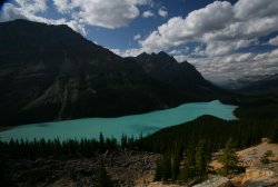
And the final highlight caps the Icefields Parkway on the southern side: Peyto Lake. Named after “Wild” Bill Peyto (you probably remember the saloon named after him in Banff), this lake is probably the nicest among scores of world class lakes on the drive. We parked, made our way, waited for the tour bus of people to disperse, then hopped the fence to get some good photos. A German woman called out “Excuse me!” which Dan didn’t hear (though I did). Then “we’d like to take a photo,” to which Dan replied, “I’ll just be a minute”. At this point her husband piped up, “We’ve been here already for 10 minutes” and Dan, “No you haven’t. WE haven’t been here for 10 minutes” “Well, maybe five minutes” the man replied, but he’d already lost. Now, this isn’t a confrontation I’d like to have, and I definitely can appreciate wanting people out of your photo, but it seemed they were going a bit far. Dan’s responses were rude and I felt embarrassed, but then they were pretty rude to begin with. Why is their photo more important? We really had only been there for about two minutes and I’d already gotten out of the way behind a tree for their benefit. The more I thought about it, the more it was just kind of funny.
Anyway, we got our photo of Peyto Lake, though the light wasn’t ideal it was still pretty nice. Still, Dan wanted to come back in the morning for another photo and I was up for it. We had now entered Banff National Park, incidentally, and we found a nice campsite in Lake Louise then came back the next morning. I was shocked at how much more beautiful this lake looked lit from a different angle. In fact, I was shocked it could even look better than it had the day prior, but here was evidence. You can be the judge, too. From Peyto Lake, we drove down to Bow Lake to look around and then to Lake Louise. I had to the overpass many a time, turning to go ski the slopes at LL, but only once before had I been to the actual lakeside, when I was very young. I don’t really remember it even, but I have seen photos. So it had a sort-of familiarity that probably wasn’t merited but there it was.
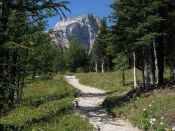
We set out from the hotel at the base of LL to hike to the glacier that backs it, specifically The Plain of the Six Glaciers trail. It takes you along the edge of the lake and then up into the mountains for, you guessed it, a view of six glaciers up there (though I only saw five). There’s also a teahouse up there for anybody looking for an excuse to exercise that doesn’t involve scenery or photography, but we didn’t stay for tea. We had another walk to Mirror Lake off the upper trail back, so we didn’t have to double back on our trail. All said, it was 16 km on top of some early morning photography. The trail was nice and the hike was worth it, though next time I’m going to have some mountaintop tea. Maybe because it was tradition in Asia, maybe because I like the idea of doing something patently out of context on a mountaintop, like sipping tea, I’m not sure. But it felt wrong to skip it.
Our third day brought us to something that Dan had been looking forward to since the airport in Vancouver – Morraine Lake. In fact, I think that a friend’s photos of Morraine Lake are what brought Dan up to Canada in the first place. We caught Lake Louise at sunrise and were at Morraine Lake to take photos for the golden hour, which in this particular location’s case, was 10 or 11. Climbing up to the vantage point I took the unfortunate path of walking across logs in shallow water, not realizing until too late there had to be a better way. Which was right when I slipped in. I sloshed my way to the top of the rock pile that gives Morraine Lake its name and there was the million dollar view. Or should I say twenty dollar view – the view spread out in front of me is one that I’ve seen many (well, not as many times as I’d like) times before: on the back of our old $20 bill. A solid hour of scrambling and attempting different photos while trying to dry my socks and shoes and having a snack later, we were back at ground level and setting out on our next hike: a three hike combo of Larch Valley / Sentinel Pass / Paradise Valley.
The hike would take us over the back of Morraine Lake through an alpine larch valley (appropriately named, you see) to Sentinel Pass, which rose between two mountains and featured tall stalagmite-like pillars of stone rising like guards (or sentinels, if you will) watching both valleys. From there it was a scramble down some pretty loose scree to Paradise Valley which, to be honest, was a rather boring hike with a few nice spots spread way too far out and guideposts that displayed random numbers of kilometres. The whole deal was 17 km and we had to hitchhike back to the base of Morraine Lake. Well, by we I mean one of us (it’s scary to pick up one person much less two). Dan tried first and was on his last car before it was my turn when some people pulled over and drove him down the road where we were parked. Dan picked me up, again, and our last day was concluded. Tomorrow, we were crossing back into BC to visit Yoho National Park, then back to Banff for a day before it was time for me to get home and Dan back to the States.


2 comments:
Dear Author dean.katsiris.com !
The helpful information
I want to quote your post in my blog. It can?
And you et an account on Twitter?
Post a Comment