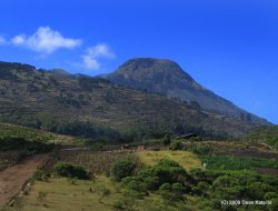
I quickly loaded my pack with gear and refilled my water bottles (5 L in all) while everybody was loading their packs into the back of the pickup. We were setting off at 5:15 AM for the highest point in Central America, Tajulmulco, about three hours north of Xela close to the Mexican border. Quetzaltrekkers, the company I was travelling with, provided almost all of the gear including a backpack, so I stashed my own backpacks in their office along with valuables and we were off to catch a bus. The bus ride was to San Marcos, which in the morning sun felt a little like Kunming. I think this may be because it was a fairly large centre and Kunming was the last place I remember waking up on a bus and arriving at dawn. We had a nice breakfast (included) and grabbed another bus for a small town at the base of Tajulmulco, which isn’t just the highest point in Central America at 4220m (about 13,000 ft), but a dormant volcano. The highest I have ever been is 4670m in the Himalayas, and I had been more acclimatised by living at higher altitudes in Lijiang, Shangri-La, and finally near Dequin before doing this trekking. Here, I had just come from Lake Atitlan, which is maybe 1500m ASL to Xela at 2335m ASL the day before and so would be hiking at elevations almost 2km higher than I was acclimatized. I was a little worried about altitude sickness, but it hadn’t occurred to me until we were discussing it on the way there.
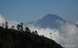
Speaking of on the way, I went to take a photo of the crowded chicken bus while en route. It was then I discovered my camera’s memory card was still in my netbook, as I had backed up my photos the night before. I effectively had no camera for this fairly epic trek. I was not impressed and bordered on distraught, though I tried to think that this would allow me to focus on just enjoying things. When I mentioned this plight to others in the hopes that they might be carrying an extra SD card, Sam told me he was a terrible photographer and I could use his card if I’d give him the photos after. This was unspeakably nice and I hope I got him some photos he is happy with. Our group, by the way, was nice and small. Myself, a Kiwi named Shane, and two Americans named Sam and Celina that may or may not have been together. We also had two guides, Scott and Sara, from Seattle and Ottawa respectively. The hike started on a dirt road through farmers’ fields, and we passed a few locals working and hauling wood while we made our way upwards towards the looming dome of Taj, which is what I’m calling it even though the ‘j’ in Spanish is an ‘h’. We could also see the distant mountain, which forms part of the border with Mexico.
As we climbed I was fine, the altitude not really getting to me aside from heavy breathing and a slowing pace. Celina was having difficulties, however, and popped some Motrin for her headache. We picnicked in an alpine meadow for lunch watching the clouds for below and eventually above as well. I began to notice the very beginnings of a headache myself, which worried me, but I didn’t take anything for it because I wanted to know if it got really bad. Headaches, stomach pain, dizziness, nausea, and of course shortness of breath are the body’s way of telling us we’re from the prairies and have no business scaling mountains. I wanted to know if I was about to die from it. We pressed on and as we were moving it disappeared, probably more forgotten than gone, into an alpine forest and into cloud and mist. Occasionally, the clouds would break above to offer some warming sun, but generally it was mist everywhere, which added an ethereal effect to the forest around us. We stopped at one point to watch a couple locals gathering wood by throwing a log on a rope around a branch, winding it around, and then pulling as hard as they could. The first few efforts it unwound and came screaming at them, but finally they managed to break the branch and send them on their butts.
By the time we reached our so-called base camp at about 4000m, my head was pounding pretty good and I had lost pretty much all my energy, collapsing on my backpack in a huff, both happy to be done for the day and utterly exhausted and out of breath. As we set up camp, my headache grew worse and I took two Tylenol to help combat it. We climbed further to a lookout to watch the sunset, which was both chilling and fantastic as the clouds whisked around our peak obscuring and then revealing amazing views. Back at the bottom, the camp stove was boiling water for hot chocolate. I could barely drink mine at this point and I tried to sit with the others around the stove but I just couldn’t, so I went and laid down in the tent thinking I was likely to throw up at any minute – a bad idea since dehydration is not good for altitude sickness. So I fought it and the growing fever, throwing off all my warm layers in the sleeping bag and feeling like a furnace. I actually fell asleep for a bit, the time being around 6:30. They woke me for dinner and I felt a bit better though I had no appetite whatsoever, which is yet another symptom of altitude sickness, though I still forced down about a spoonful of pasta before retiring to the tent again. I felt terrible and was pretty worried about my health since I know that altitude sickness can be fatal and I wasn’t sure how far along I was in that progression. Interestingly, although Celina had been having more problems than I had on the climb up, she now seemed fine. It’s a funny condition, this one. We climbed to a small rise to watch the sunset, which was less impressive than the clouds zipping around us, and went to bed.
I slept pretty well considering I had no pillow and was fully bundled in all my cold weather gear. I did wake up any number of times to take a look at the almost full moon (read: bathroom – I’d drank almost 4L of water that day) and discovered that Celina was now worse off than I was with severe cramps and everything that goes with it, not to mention nausea. When I woke up at 3:30 in the morning, I was fine aside from a slight headache which I took two Tylenols for again. In spite of this, we ascended to the top of Taj in pretty good time without needing torches thanks to the brilliant moon, all of us (including Celina though she was feeling terrible), with our sleeping mats and sleeping bags to sit in as we waited for sunrise. This was comfy, though as soon as the horizon started lighting, I couldn’t help but wander around looking for photos. Sunrise was among the most spectacular I have ever seen – I can’t think of a better one, but there have been many greats alongside it. We could see into Mexico. We could see all the way to Antigua, with distant Fuego erupting and sending a smoky finger into the sky. We couldn’t see the Pacific as it was hazy in that direction, but it was there. I took a lot of photos.
We descended around the old volcano crater, a beautiful walk back to base camp in the light of a new day. Breakfast, which I again stomached (still no appetite), looking over northern Guatemala, and our hike down which went pretty quickly to the bottom along a ridgeline that also offered spectacular views. Although the mist was ethereal yesterday, what it had been concealing was stunning. It really is a beautiful country and I reaffirmed that this hike had been worth all the altitude issues and heavy breathing, not to mention the detour from Atitlan and my path south to get here. My stomach served as an altimeter and I noticed my growing hunger with each step down the mountainside. When we reached the bottom, there was a very out-of-place skier-type restaurant waiting for us with shrimp tacos, sour oranges (lime on the outside, orange on the inside), rice, beans, soup, potatoes, and a virtual feast for 20 Q (although it was, again, include), not to mention juice. Hungry as I was, for the first time in Central America, I couldn’t finish. We stuffed ourselves, and so the irony of seeing a pig wandering down the street when we left was not lost on me. Two long bus rides back and a hike through Xela and we were back home.


No comments:
Post a Comment